Habitat is a critical concept in ecology and is defined as the resources and conditions present in an area that produce occupancy by a species. Because of differences in habitat requirements, different species will alter their space use based on resource availability and environmental conditions within a landscape. As part of my research, I use advanced remote sensing techniques to assess landscape characteristics and quantify their effect on animal space use. These characteristics comprise both environmental and anthropogenic aspects of the landscape and provide insight into ecological relationships and human impacts on ecosystems.
Forest floor vegetation structure increases mammal habitat use and diversity
To assess the effect of habitat structure among other conditions on mammal space use, we collected forest floor habitat data using VegSense in the Udzungwa Mountains National Park in Tanzania in tandem with camera trap data on the ground-dwelling large mammal community. In a study published in Ecology, we identified a strong effect of habitat surface area on mammal abundance and functional diversity using a cutting-edge multi-species occupancy model.
To assess the effect of habitat structure among other conditions on mammal space use, we collected forest floor habitat data using VegSense in the Udzungwa Mountains National Park in Tanzania in tandem with camera trap data on the ground-dwelling large mammal community. In a study published in Ecology, we identified a strong effect of habitat surface area on mammal abundance and functional diversity using a cutting-edge multi-species occupancy model.
Assessing forest floor vegetation structure
To measure landscape heterogeneity, we developed a novel remote sensing application for the Microsoft HoloLens, called VegSense, which we used to map and measure habitat structure on a fine scale in forest floor ecosystems. The HoloLens is a head-mounted mixed-reality device. The application VegSense allows its user to remotely scan their surrounding environment while walking through it, with real-time images of the scan projected on the HoloLens’s mixed-reality screen. In a paper in Methods in Ecology and Evolution, we showed that the new application was capable of accurately calculating a variety of forest floor habitat metrics including DBH of mature trees and plot-level vegetation complexity.
To measure landscape heterogeneity, we developed a novel remote sensing application for the Microsoft HoloLens, called VegSense, which we used to map and measure habitat structure on a fine scale in forest floor ecosystems. The HoloLens is a head-mounted mixed-reality device. The application VegSense allows its user to remotely scan their surrounding environment while walking through it, with real-time images of the scan projected on the HoloLens’s mixed-reality screen. In a paper in Methods in Ecology and Evolution, we showed that the new application was capable of accurately calculating a variety of forest floor habitat metrics including DBH of mature trees and plot-level vegetation complexity.
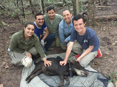
Herbivore impacts on forest vegetation in a fragmented landscape
Conducted as a field study in the Cerrado and Pantanal of Brazil, this project examined the vegetation community response to white-lipped peccary movement in a fragmented agricultural landscape. This project was funded by the Littlejohn Fellowship and the Vanderbilt University Summer Research Program.
Conducted as a field study in the Cerrado and Pantanal of Brazil, this project examined the vegetation community response to white-lipped peccary movement in a fragmented agricultural landscape. This project was funded by the Littlejohn Fellowship and the Vanderbilt University Summer Research Program.
